Example Result Scenes and Update Objects
|
The following program shows how to use result scenes and update objects of GeoWin. (See also Example Result Scenes and Update Functions.) The update object |
|
|
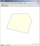
The main function defines a The boundary drawing color for Finally, On the right there is a screenshot of the program after adding
some points interactively. Clicking on the picture shows the |
 |
#include <LEDA/graphics/geowin.h>
#include <LEDA/geo/float_geo_alg.h>
using namespace leda;
int main()
{
GeoWin geow;
list<point> LP;
geo_scene sc_points = geow.new_scene(LP);
//edit scene for input of points
geowin_update<list<point>, list<polygon> >
convex_hull(CONVEX_HULL_POLY);
geo_scene sc_hull = geow.new_scene(convex_hull,
sc_points, "Convex hull");
//result scene for convex hull
geow.set_color(sc_hull, blue);
geow.set_visible(sc_hull, true);
geow.edit(sc_points);
return 0;
}
|
|
See also:
Example Result Scenes and Update Functions
Basic Data Types for 2D Geometry